The BolognAbile project was born in 2017 thanks to the "Bologna Made" initiative promoted by the Municipality of Bologna. It was designed to be a participative process from different points of view: from civic crowd mapping to the creation of tools that, both on a digital and sensory level, can build connections between people, places and cultural content, generating accessibility on various fronts according to the principles of universal design. For some years, Bologna has been growing as a tourist destination, both nationally and internationally, an increasingly diversified tourism market in terms of age, origin and type of stay. But there is still a range of "audiences" who find it difficult to fully enjoy the city of Bologna, both as tourists and as citizens or city users as well: these are the most vulnerable categories, not only persons with disabilities, but also the elderly, parents with young children, immigrants with language difficulties.
.jpeg)
It is estimated that there are more than one billion persons with disabilities in the world. In Italy alone there are approximately 3.2 million people, of which 2.5 million are elderly, people who want to travel, learn, access public spaces with the greatest possible autonomy. An inclusive city is a city that rehabilitates people to gain their right to use these spaces. In this sense, tourism can become an opportunity to build bridges between people, effectively becoming a social vehicle through exchange, gathering, knowledge, and complete and responsible use. Stemming from these assumptions, the BolognAbile project aims at making Bologna a more enabling city for its citizens and for city users and tourists as well, and merging a culture of hospitality into the community and social fabric. Thinking of the city – and thinking of it as skillful and empowering – is not only the task of the administration, but a duty for all those involved in its cultural, tourist, economic or productive purposes. In this context, it was decided to begin work from the mapping of public spaces accessible to all: gardens and parks for which visual and tactile maps have been created for orientation within and in their surrounding areas, indicating where to find accessible paths, resting areas, and possible obstacles. In this first project phase, 13 parks and gardens were chosen, that is two parks for each neighbourhood, except for Santo Stefano, where a third park was added, Margherita gardens, as these gardens are the closest and most popular in the area of the Institute for the Blind Francesco Cavazza. By definition, green areas are public: with its biological activity it allows our planet to breathe, to stay alive. We often perceive gardens as gaps between houses, where plants grow. In reality they are an extension of the idea of a city: why does this park has this shape? Why those trees? The discipline of urban parks is today subordinated to the construction of the city in a physical sense, but the fact remains that a garden is the place where biodiversity is most important. So it is important to be able to observe them with the right tools. Tactile maps help people living with vision loss to get around, beginning with the knowledge of small elements to a more complex representation to be explored and learned about through experience. The choice of quantity and quality of information depends on the tactile threshold and the size of the map. The first essential elements of information concern the park surroundings: the roads in the perimeter, with bus stops and pedestrian crossings safely leading to the park entrances. These are simple signs making up a structure which allows people to experience and build a personal mental mapping: it is a first composition bringing to mind the park's shapes, paths, and special features. Maps are designed for everyone, so alongside the tactile relief, there are simple chromatic elements that help to differentiate green areas from paths, and trees from other elements. What is represented helps provide a sense of orientation within an area which would otherwise be unknown. Maps also contain useful information on activities and services for all audiences. Simple legends support map reading and understanding of the park area.
Botanical information is also provided through the representation of trees characterizing each of the mapped parks allowing people to understand the botanical and landscape heritage of Bologna's gardens, even for those who do not see.

To describe parks, it was chosen to use the text found on green signs placed at the entrance gates – which may be inaccessible not only for visually impaired people, but anyone, because they are damaged or illegible – ensuring that the experience is as inclusive as possible for everyone. In parks where it was not possible to use these signs because there was none, an introductory text was written relating to their historical and environmental characteristics.
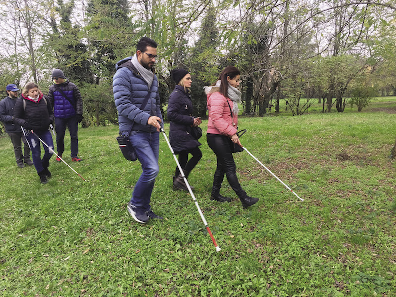
Each map associated with its herbarium charts and descriptive text led to the development of the tactile guide Cammini in Verde [green paths]. In order to achieve this result, the first working stage was the mapping of the chosen green areas, to evaluate their usability and learn about their services. Eight visually impaired and blind people from Bologna and elsewhere participated in the development, as well as four persons with cognitive and physical disabilities who are guests at the residential centre Casa Rodari, managed by CADIAI, a social cooperative. Furthermore, some explorations for mapping were done with experts from onDATA.it, an association for the promotion of data transparency and collection for OpenStreetMap content and the integration of information useful in achieving accessibility.
Font type and size for texts in black were also determined to promote easy reading for as many people as possible: the EasyReading font is in fact a high-legibility typeface for people with low vision or dyslexia. Texts are also presented in braille, maps and legend are made on microcapsule paper and the herbarium graphs are made in relief print. The guide was printed and bound by Grafiche Zanini, while the tactile sections were made at the Institute for the Blind Francesco Cavazza.
The paper guide was introduced with a Facebook page and a website. For the necessary content, a training internship was developed for six visually impaired and blind people, all awaiting employment, to provide them with the basic skills to become social media strategists and copywriters.
Through the BolognAbile project, we like to think that it is possible to make Bologna a more inclusive city, enjoying its gardens as places of "living" culture, conceived and designed based on criteria of beauty, understood as a multisensory experience: not only a visual experience, but one extended to the perception of the atmosphere, as well as sound and tactile sensations.


.png)