Architecture
and City
at Hand's Reach
by Paola Bucciarelli
Results of the important research on the study and production of
visual and tactile
maps by C.I.F.R.A. at Bologna's Istituto F.
Cavazza.
The fear of getting lost in unknown or known areas originates in the
necessity, common to each individual, to be in control of one's own
actions.
The sensation of time and space disorientation is more common for
blind people and this often leads to the unwillingness of going through new
routes in vast areas. For those who do not see or who have severe problems of
low vision, the difficulty lies in the inability to simultaneously perceive
reality, grasp at a glance a world, which cannot be perceptibly rebuilt through
the sense of touch or anticipated through acoustic sensations.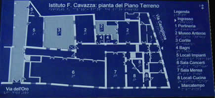
Visual and tactile maps are a valuable tool to help with
these difficulties. They are graphical representations in raised lines of
natural and artificial environments with colour contrats and descriptions in
print and Braille, studied to facilitate orientation and recognition of wide
areas. These maps are particularly, but not exclusively useful to blind
persons.
Based on these concrete cognitive demands (which matter daily to
millions of people who everywhere in the world are moving about, studying and
travelling for work or pleasure), the Istituto F. Cavazza has begun an applied
and basic research - entrusted to HBgroup in Milano - concerning design methods
and techniques as well as production technologies of visual and tactile maps of
architectual, urban and territorial environments.
Systematically placing
planimetric representations of architectual and urban environments in relation
to visual and tactile perceptions has allowed to gain some insight on positivity
linked with the adoption and the use of maps to see and touch. They are
instruments providing information and are conceived in inclusive terms able to
provide immediate answers to so many different 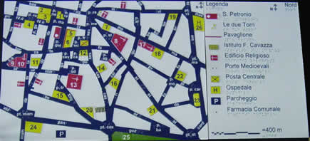 needs of persons who have different characteristics,
reading and interpreting capabilities. For that reason, since the very beginning
of the project, the methods, the content and the results have been interpreted
and managed keeping in mind the study principles of inclusive design:
compatibility, adaptability and flexibility, normality of images, simplicity of
use, good quality and price ratio, safety and reliability.
needs of persons who have different characteristics,
reading and interpreting capabilities. For that reason, since the very beginning
of the project, the methods, the content and the results have been interpreted
and managed keeping in mind the study principles of inclusive design:
compatibility, adaptability and flexibility, normality of images, simplicity of
use, good quality and price ratio, safety and reliability.
The work of
research - structured in phases of analysis, experimentation and synthesis - was
realized structuring, revising and updating international multidisciplinary
knowledge - theoretical and empirical, present and past - in relation to the
make up and production of maps in respect to reading capabilities of sighted
people, people with low vision linked to colour perception and visual acuity,
and blind people.
One of the most considerable results is the perfecting of
an abacus of 191 tridimensional symbols of chromatic contrasts of variable
height and sections: an alphabet from which to create maps brought to scales of
variable representations between 1:50 and 1:100,000.
The acquired knowledge
at the basic and empirical levels, with the experimental prototypes and two maps
with legends (the first one representing the first floor of the Istituto Cavazza
and the second one the south east part of Bologna's historical centre) has been
discussed and examined in detail during the project's three phases by a
scientific committee and working group composed of people who are blind and low
vision. Their contribution to the project has been extremely valuable.
The arguments discussed have been summarized in a manual
which will shortly be published (a first run of 150 copies is planned), aimed
mainly at researchers, project managers and producers of visual and tactile maps
who wish to work based on a rigorous, multidisciplinary and inclusive approach
on the matter of representation. The title of the document, accompanied with a
CD-ROM which includes the analytical and experimental phases, is called CiVis:
metodi e tecniche per la realizzazione di mappe visuo-tattili architettoniche,
urbane e urbanistiche (Methods and Techniques for Making Visual and Tactile Maps
Relating to Architecture, Urbanism and City Planning).
To experiment on the
reliability of the proposed method in relation to the development of general
maps for orientation and mobility for urban and city planning, the Istituto
Cavazza has begun a collaboration, last December, with the Quartiere di of Santo
Stefano in Bologna to create, before May, three other visual and tactile maps in
the city environment.
The research, the developed maps and the manual will be
introduced to the public on the occasion of a conference organized by the
Istituto Cavazza to present the initiative and stimulate a
multidisciplinary debate.
To know more:
Web site of the Istituto
F.
Cavazza of Bologna.
http://www.cavazza.it
Realization and production of
tactile and coloured maps for blind and low vision
http://www.cisad.it/archivionewsletter6.php3#mappe
Progetto
CiVis/P.S.P.M.T. Progettazione di un Servizio di Produzione di Mappe Tattili
http://www.hbgroup.it (accesso dall'icona progetto P.S.P.M.T.)