In the debut album of the Doors, there is the famous
Whiskey Bar song (Alabama Song), inspired by preceding work by Kurt Weill
and Bertold Brecht in which at a certain point a lost Jim Morrison asks:
Show me the way / Oh, moon of Alabama. In the tormenting lyric is hidden a
common place, a topos of our way to think and act foreseeing that whoever
has more developed senses (sees more, feels more, is brighter) is able to
show the way to whatever place to one who sees less, feels less and is
less bright, or in general lives with whatever undermining or disabling
condition. To sum up, it seems that in our world, street maps can only be
designed by abled-bodied people (or even those who have presumed superior
powers, like the moon). Now, what we like of the new wave relating to the
Web and its technologies is that these often cause some distress in our
common places; they question our presumptions, and often offer hope
and possibility for those whom until now had had few. In short, in this
article, we will demonstrate how the mechanisms used to create maps,
designed by Google and appropriately modified with an algorithm developed
in collaboration with the University of Padova and the University of
Bologna, call into question people with disabilities (visual, physical,
etc.) in order to create their maps so precisely that it almost seems no
topographer could succeed in doing. Here is how. Let's begin in 2009, when
in San Francisco took place the Web 2.0 Summit during the course of which
Tim O'Really and John Battelle proposed a clear analysis of the new
directions of the Web underlying how: Web 2.0 resides entirely in the use
of collective intelligence. [1] In substance, the Web is changing skin,
projecting itself towards the ability to recuperate, manage and understand
data generated by users in real time. Moreover, the widespread
dissemination of smart phones, telecameras and sensors are pushing
progress beyond the era of the personal computer, generating an integrated
world with devices that do their work in a pervasive manner (the era of
pervasive computing [2]). The concept of Web service is changing: Web
applications are not necessarily simple programs any more that take
advantage of a static Web platform; they can represent an instrument able
to aggregate a multitude of small contributions to generate a significant
assistance towards others [3]. As far as we and our maps are concerned, it
is easy to begin sensing how it is possible to take advantage of the
collective intelligence through the use of already widespread existing
sensors (for example, the GPS on the smart phone) to generate an
innovative service socially useful: a generator of accessible itineraries
for people living with vision loss. In fact, services like Google Maps
intended to find the best route between two places offer only the
possibility to find the shortest route by foot, car or bus. They do not
take into consideration the fact that the stretches of road could include
architectural barriers or other difficulties. It would indeed be useful
for a person with disability to be able to choose the best route that
would take into account particular physical conditions. In fact, the
shortest route is not useful to someone in a wheelchair if it does not
include accessible ramps on the sidewalks, and it is not useful either to
a visually impaired person if crossing lights do not have audio signal
devices. Rather, these users would find it more useful if a route is a
little longer, but if it guarantees the accessibility of all its stretches
of road. To create this generator of accessible routes, it is not possible
to count on staff to control regularly every single street of every city.
It would result in enormous work, in practice, impossible to do and maybe
even useless because unexpected road works could invalidate the data which
would lead to an inaccessible (temporarily) stretch of road recorded as
being accessible. Instead, it is necessary to have a distributed approach
able to capture collective intelligence thanks to the widespread presence
of smart phones and the paradigm of pervasive computing. The objective is
to generate automatically the mass of data necessary to put together a Web
service for the generation of accessible itineraries. In more details,
each day people (with or without disability) repeat the same itineraries,
for example, the route from home to work, or to the favourite bar or shop.
This observation demonstrates how it would be possible to share in a very
simple way the experience and information on some itineraries. In
substance, if a person with mobility issues uses often a determined
itinerary, it is probable that this person judges that it is accessible
because otherwise they would have chosen another one. Consequently,
capturing information on this frequently used route, it could be suggested
that other persons with similar disabilities could use it as well.
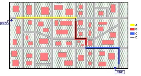
Better yet, it could be possible to collect in a database all the stretches of road frequently used by a person with a particular disability. Such information could be invisibly generated through smart phones equipped with a GPS and connected to the Internet and, once connected, they could be used and combined to a Web service to calculate new itineraries accessible to users who had made the request through the Web. For example, in Figure 1, we present a plausible scenario (a neighbourhood in a city) where A, B and C are three regular itineraries most often used by three different users with disabilities: Andrea, Beatrice and Carlo, respectively. Andrea does route A every day (in yellow in the figure) to reach his place of work; Beatrice, every other day, does route B (in red) to purchase her favourite newspaper; and finally Carlo, at least twice a week, uses route C (in blue) to go to his physiotherapist. These are all accessible itineraries that Andrea, Beatrice and Carlo have discovered through practical experience and that are now their favourites in order reach their respective destination. Let's now imagine that Andrea, Beatrice and Carlo have a smart phone equipped with a special application able to find frequently used itineraries (and so even A, B and C) and to transmit the relative information to a remote server. This information could then be made available to everyone through a Web service. As a matter of fact, let's pretend that at this point David, a fourth person with similar mobility problems, has just arrived in the city and does not know anything concerning the accessibility of the streets in that neighbourhood. David wants to go from point BEGINNING in Figure 1 to
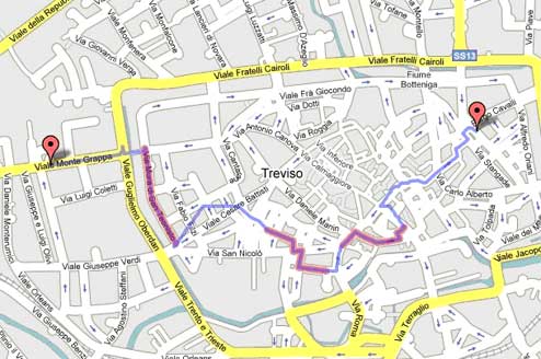
for that user (text, video, audio, images), transforming the content on the basis of the context in order to guaranteed the best accessibility; transmit periodically to the competent community office (or state) an email with an attachment the main complaints of non accessibility made by users; automatically update information on accessibility and obstacles also on other media (ex., Facebook groups, newsletters, websites, carousel of digital television), transforming its content on the basis of the requested format by the media. Of course, as we indicated at the beginning of this article, it is not a question of only good intentions and futuristic vision. In fact, we have already implemented, through a collaboration between the University of Padova and the University of Bologna, a prototype version of this service taking advantage of the last generation of smart phones (in particular, using the Google Android operating system) and putting in place a Web server for interrogation on the part of users who want to know about accessible routes between two points. The result of these interrogations is visible in Figure 2 which demonstrates the user the initial and final points of the route offered (in red), the distance (in violet) and the accessible streets (in fuchsia) as it was retrieved from the database. The itinerary generate for the example in Figure 2 does not guarantee full accessibility of the route, but only the accessibility of the streets in fuchsia. For the rest, it was not possible to determine accessible itineraries in the area because the database contains too little information.
As it is known, in fact, the efficiency of a participative application like the one we are designing is more important with a great number of users who take advantage of it, making available their small contribution for information. With the passage of time and the increase in the number of users, the available service is bound to improve in an independent manner. The database will be filled with itineraries considered to be accessible and therefore the suggested itineraries will be composed of accessible stretches in a greater measure than those on which no information is available. So, in conclusion, people with visual, vocal, hearing, physical disabilities, help us build our sensible maps because without you they will not be as useful!
References
[1] T. O. Reilly, J.
Battelle, "Web Squared: Web 2.0 Five Years on" [online]
http://www.web2summit.com
/web2009/public/schedule
/detail/10194,
2009 [2] Weiser, Gold, Brown, "Ubiquitous computing", 1999-05-11 [3] S.
Ferretti, M. Furini, E. Palazzi, M. Roccetti, P. Salomoni, "WWW Recycling
for a Better World", Communications of the ACM, ACM, vol. 53, no. 4, Apr
2010
Marco Roccetti is a full professor at the Department of Information Sciences at the University of Bologna where he teaches Internet Architecture and Multimedia Systems and Applications. His research interests are focused on the Internet and its applications.
Claudio E. Palazzi is a university researcher at the Department of Applied and Pure Mathematics at the University of Padova. He teaches Operating Systems and Wireless Networks in the Computer Science Bachelor Program. His research interests include computer networks, Web 2.0 systems and applications for mobility devices.